Mere, Belgium
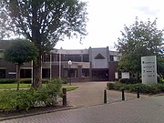
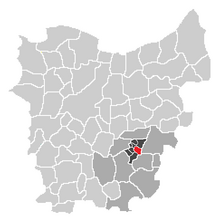
Village in Flanders, BelgiumMere is a sub-municipality of Erpe-Mere in Flanders. It is located on the Molenbeek-Ter Erpenbeek in the Denderstreek in the southeast of East Flanders and belongs to Arrondissement of Aalst. It is bordered by the sub-municipalities of Erpe, Ottergem, Bambrugge and Aaigem and the municipalities Haaltert and Aalst. Mere has 5033 inhabitants as of 1 January 2003 and an area of 5.77 km. The population density is 873 inhabitants / km ².
Read article
Top Questions
AI generatedMore questions
Nearby Places

Erpe-Mere
Municipality in Flemish Community, Belgium

Haaltert
Municipality in Flemish Community, Belgium

Arrondissement of Aalst
Arrondissement of Belgium in Flanders

Erondegem
Village in Flanders, Belgium

Ottergem
Village in Flanders, Belgium

Vlekkem
Village in Flanders, Belgium

Egem, East Flanders
Hamlet in Flanders, Belgium

Ninove Abbey
Church in Ninove, Belgium


